 My assignment was to drive
to Durango and meet up with a representative from the Western Energy Project to
photograph potential oil and gas leases near national park boundaries…in this
case, nearby Mesa Verde National Park and Chaco Canyon in northern New Mexico. Just to keep things interesting, I took the
long westerly route. That first day's
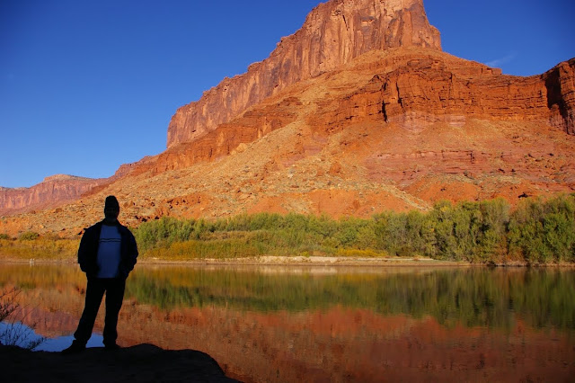
drive through Moab and down along the edges of the canyon country added an
extra hundred miles or so but I had all day and I wanted to see the desert in
bloom, and reconnect to some rock art, and just once again be amazed at the
diversity of this country. Just outside of Cisco, Utah the globe mallow
and sego lilies were in a blooming frenzy, covering the normally barren landscape
with color.
My assignment was to drive
to Durango and meet up with a representative from the Western Energy Project to
photograph potential oil and gas leases near national park boundaries…in this
case, nearby Mesa Verde National Park and Chaco Canyon in northern New Mexico. Just to keep things interesting, I took the
long westerly route. That first day's
drive through Moab and down along the edges of the canyon country added an
extra hundred miles or so but I had all day and I wanted to see the desert in
bloom, and reconnect to some rock art, and just once again be amazed at the
diversity of this country. Just outside of Cisco, Utah the globe mallow
and sego lilies were in a blooming frenzy, covering the normally barren landscape
with color.
South of Moab, I took a
detour toward Newspaper Rock, not far from my old Canyonlands haunts in the
Needles country. As I dropped down the
Dugway, the canyon of Indian Creek came alive in bursts of lime green from new
spring foliage. Cottonwoods. Box elder.
Gambel oak. After a brief stop at
Newspaper Rock, I drove a little further along highway 211 looking for other
rock art sites not marked for the general public. In spite of the fact that it was Memorial Day
weekend, there was very little traffic.
From the edges of
Canyonlands I turned around and drove up Harts Draw, over the Abajo Mountains
through aspen and fir forest before dropping down again into the pinto bean
farm country of western Colorado and the hustle and bustle of Durango. Magnificent
dynamics in the highs and lows of the landscape.
I met Ti on Friday morning....a lanky young man in his late 20s, I would guess. Easy going. I didn't feel any condescension or discomfort. With his maps, we drove down several county roads looking at potential drill sites and their impacts on the Mesa Verde view shed. And I took my photos of same. We spent a large part of that first afternoon in Mesa Verde before heading south to Farmington, New Mexico which is the total antithesis of a Colorado mountain town like Durango. Farmington is rife with industry. Pickup trucks. Cheap hotels. Fast Food. And drill pads and well sites everywhere.
I met Ti on Friday morning....a lanky young man in his late 20s, I would guess. Easy going. I didn't feel any condescension or discomfort. With his maps, we drove down several county roads looking at potential drill sites and their impacts on the Mesa Verde view shed. And I took my photos of same. We spent a large part of that first afternoon in Mesa Verde before heading south to Farmington, New Mexico which is the total antithesis of a Colorado mountain town like Durango. Farmington is rife with industry. Pickup trucks. Cheap hotels. Fast Food. And drill pads and well sites everywhere.
 Hot. Dusty. Ugly.
Probably the worst way to enter New Mexico, "the land of
enchantment". Be that as it may, on Saturday we drove down to Chaco
Canyon and once we were actually in the park itself, it was hard not to get
caught up in the depth and level of sophistication of the people who once lived
there. I wandered alone through abandoned doorways at Pueblo Bonito
before taking on the moderately strenuous hike to Pueblo Alto, an un-restored
ruin site with unobstructed views north toward possible drilling rigs.
Hot. Dusty. Ugly.
Probably the worst way to enter New Mexico, "the land of
enchantment". Be that as it may, on Saturday we drove down to Chaco
Canyon and once we were actually in the park itself, it was hard not to get
caught up in the depth and level of sophistication of the people who once lived
there. I wandered alone through abandoned doorways at Pueblo Bonito
before taking on the moderately strenuous hike to Pueblo Alto, an un-restored
ruin site with unobstructed views north toward possible drilling rigs. The rest of the day was spent on more back county roads looking at drilling leases. Not a pretty site. But maybe some of the photos I took will be persuasive enough to help the Western Energy Project people with their cause. I was able to get a nice early start on Sunday morning for the drive back to Durango. Incredible clouds in the sky as the sun rose just south of the Colorado border. I linked up with Tom, an old park service friend of mine, for breakfast in Durango. I've known Tom since 1971. He is my oldest NPS friend and, like me, long since retired and now living in Pagosa Springs. We don't see each other all that much so it was nice to have the time with him. And then, of course, there was the spectacular finale for me....the drive up and over the Million Dollar Highway through Silverton, Ouray, over Red Mountain Pass, Molas Summit, and finally descending into the familiar angular country of theWestern Slope. And the dark hulk of Grand Mesa which always embraces me like a vagabond son.